
Tafjordfjella
At the end of July it was time for us to take a vacation from all our visitors and travel in our own style: a nine-day hut-to-hut hike in Tafjordfjella (the Tafjord mountains), near Romsdalen. Here we are on the last day of the hike, with some of the higher summits behind us. Molly and Rick climbed Karitind, on the left, while Puttegga, on the right, is the highest at 1999 m.


Here is the picturesque Reindalen where we stayed at Reindalseter one night outbound and one night coming back. Near the hut is the storfuru (big pine) a Scots pine some five or six feet in diameter, really big for these parts.


Tafjord, peeking out from between the mountains in the photo on the left, is one of the several arms of Storfjorden ("the big fjord"). Our hike took us around a mountain with a view down over the fjord, then up to Danskehytta, one of the newest huts in Norway (opened in 1994), and a very comfy one at that. Judging from all the bare rock, the area uder the hut was probably under snow year-round not so long ago.


An especially fine piece of trail between Reindalseter and Veltdalshytta. Along the way we found a 'fossil pothole', probaably formed by a river flowing under the ice, and several hundred meters above the present-day river.


Near Veltdalshytta is Fieldfarehytta, the humble and well-hidden home base of a commando operation during World War II. A group of four British-trained commandos holed up here for more than a year and made forays out to sabotage rail and telegraph lines. One of them, Joachim Rønneberg, who was also a veteran of the legendary sabotage operation on the crucial heavy water plant in Rjukan in southern Norway, returned to direct the reconstruction of the hut in 1990! We thought we might stay a night here, but it turned out to be rather too small and rustic even for us - that's about 50% of the interior in the photo on the right.
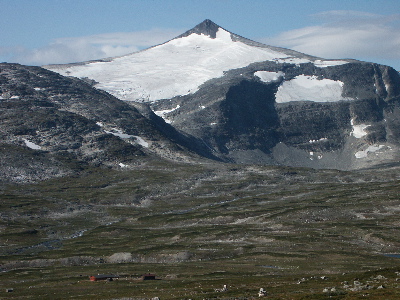
Here's another view of Karitind (1982 m), the high point of the trip for Molly and Rick, although the weather wasn't quite so nice when we were up there. That's remant glacier ice covering the flank of the mountain.

And here's Molly with some words of wisdom we found on a steep section of trail near Reindalseter:
"You can't get to the mountains
When you take a flat trail"